Flood-alert SaaS · street-level flash-flood intelligence
Flash floods start in the street. Know which street, before the rain.
A flood forecast for your own door, a countdown when the river rises, and alerts from the businesses around you. For shops, councils and insurers in England and Scotland.
Street-level maps in England (Scotland coming soon) · rivers, radar and evidence reports in England and Scotland
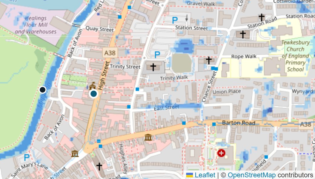 Your door: up to 0.23 m at 18:00Into doorways: move stock now
~45 min to your door
Nearby alert · 130 mDrains backing up on Church Street
Check flood risk by postcode
Live flood risk for any postcode in England or Scotland: rain and radar, rivers, official warnings and local reports. Wales and Northern Ireland: rain and radar only.
Want to see what an alert looks like?
Built on open data from
- Environment Agency
- SEPA
- Met Office models via Open-Meteo
- Copernicus
- OpenStreetMap
Live flood updates
Flood warnings today: what's happening now
Official sources and trusted news only: the Environment Agency, SEPA, the Met Office and BBC News. Checked every 5 minutes.
Loading live updates…
Follow the official accounts. Facebook and Instagram don't let other websites show their posts, so here are the real accounts, as listed on each organisation's own website.
Surface water is the most widespread flood risk in England and Scotland
And it's the one official flood warnings don't cover street by street: they're built for rivers and the sea.
How it works
How our flood alerts work: from a raincloud to the right action at your door
-
Predict where it will flood
Every hour's forecast rain is run over Environment Agency 1 m terrain: where water pools, which streets it runs down, and how deep it gets at your door.
-
Detect where it is flooding
Verified local businesses flag what they can see, and we scan news and social media for flooding on your streets, so the forecast is checked against reality.
-
A countdown to your door
Tell us the river level that reaches your door. We watch how fast it's rising: "could reach your door in ~45 minutes".
-
A plan, not just a warning
Stock checklists and sandbag steps, with every action time-stamped in a log you can give your insurer, and a monthly flood assessment. Texts to your staff: Coming soon
Neighbours and social media
A local flood network: businesses alert each other
📣 Alert nearby businesses
See water on the road or drains backing up? One tap alerts every FloodSignal business within 1.5 km, and puts it on their map.
📰 News and social media, scanned
Local news and public Mastodon posts are checked for flooding on your streets. Water depth, road closures and flooded shops are picked out automatically. Posts naming a nearby street raise your risk level.
🌊 One local flood feed
Business reports, official warnings, rising rivers, intense rain on radar and news and social posts, newest first, in one feed.
More social networks Coming soon: Bluesky, YouTube and X. Facebook and Instagram don't allow it.
Customers and pricing
Flood alerts and flood evidence for businesses, landlords, councils and insurers
Shops, cafés and high-street businesses
£29 + VAT a month per premises Or £290 + VAT a year, two months free. 14 days free, no card needed. Cancel any time.
- A street-level forecast for your own door
- Flood alerts by email, and a countdown when the river is rising
- Alerts from the businesses around you
- A flood plan, a tamper-evident log and a monthly flood assessment for your insurer
Multi-site businesses, landlords and property managers
From £19 + VAT a month per site £24 a site for 5 to 19 sites, £19 a site for 20 or more.
- Everything in the business plan, for every site
- Door-level river countdowns for each property
- Monthly flood assessments across your portfolio
- One invoice for all your sites
Councils and Business Improvement Districts
Priced per town For up to 50 businesses, with council flood reports. Email us for a price and a free pilot.
- Businesses ready before the water arrives
- Live reports of blocked drains and pooling water
- Evidence for Section 19 investigations (England) and local flood risk management plans (Scotland)
- Faster reopening after a flood
Insurers, MGAs and loss adjusters
£35 + VAT per claim check Falling to £15 a check at volume. Portfolio assessments from £1 a property a month (minimum £250), with lower rates for large portfolios. Free back-test first.
- Remote flood assessment for any address and date of loss in England or Scotland
- Screen claims in about a minute: was there flooding in the area on the date of loss?
- Spot claims dated when nothing points to a flood, with a fingerprinted evidence pack
- A free back-test on 20–25 of your past claims
- Patent-pending flood modelling
Flood event report · one address, one flood
Flood report for your address: what do the records show?
An independent flood evidence report for one address and the dates of a flood. It sets out what the river gauges, rain, radar, satellite flood maps and our street-level model show, whichever way the evidence points. Use it for an insurance claim, a landlord or tenant, a buyer, or your own records. More about flood reports.
- River levels at the nearest gauges against their normal range, and when they peaked
- How much rain fell, and how hard
- Satellite flood maps around the address, where a satellite passed over
- Whether the evidence points more to a river or to surface water
- A fingerprinted PDF, so any later change to it shows
England and Scotland, for river and surface-water flooding. Coastal and tidal flooding isn't covered yet Still working on it. The street-level model covers England. The report is information, not claims advice: we don't deal with your insurer for you. See the terms.
£49 + VAT Launch price until 30 November 2026, then £149 + VAT.
- PDF by email within 1 working day
- No useful evidence, no charge: if the data can't tell us anything about your address and dates, we refund you in full
Samples: a flood found · no flood found
Latest storm checked · 24–26 October 2026
Storm Boelo, Keswick
- The River Derwent peaked 0.58 m above its normal top, 1.7 km from the address
- 62 mm of rain, with bursts of 24 mm an hour at a gauge nearby
- The area was wet, but nothing strong enough to put water at the property: get more evidence, starting with the policyholder's photos and the water line
Example report, made from real public data
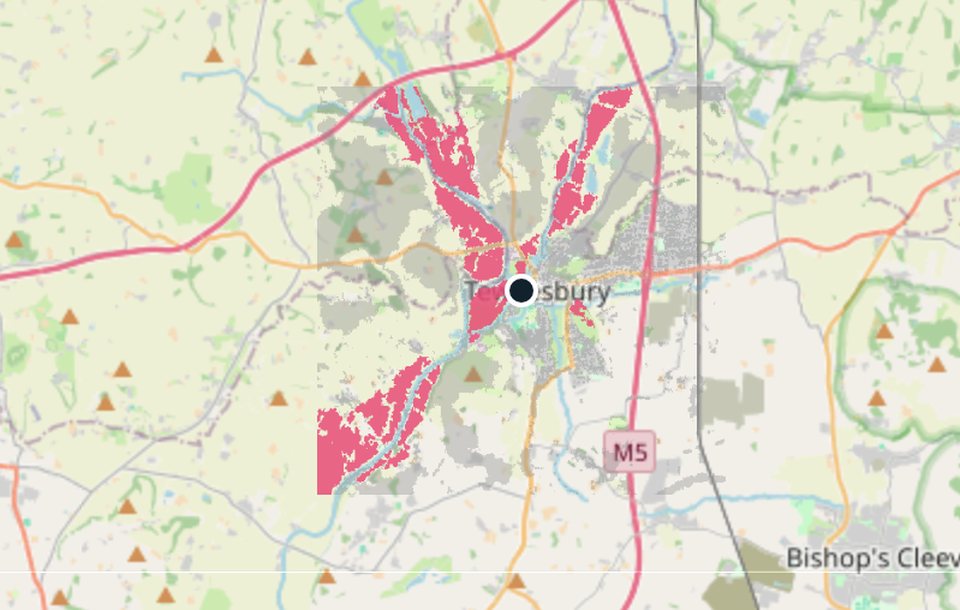
Storm Henk, Tewkesbury, January 2024
The challenge
After a flood, insurers and councils need independent evidence of what happened at one address: was it flooded, when, and did the water come from a river or from the streets?
What FloodSignal did
It brought together Copernicus Sentinel-1 satellite flood maps, the rain that actually fell, Environment Agency river gauges against their normal range, and a replay of the street-level model, in one fingerprinted report made in about a minute.
What it showed
- Strong evidence of flooding near the address, most likely from the rivers
- The River Severn at Mythe Bridge peaked at 4.83 m on 4 January, 0.99 m above its normal top, the highest in its recent record
- Satellite radar mapped 6.6 km² of flood water within 4 km, the nearest 181 m from the address
- Only 11 mm of rain fell on the town itself: the water came down the rivers, and the street model shows no significant surface water
Flood forecasting to predict floods. FloodSignal to reduce the damage.
Predict
- Radar tracking: we follow rain on weather radar every 15 minutes, check it against Environment Agency rain gauges, and project where it's heading over the next 90 minutes.
- Street-level flood modelling: the forecast rain is run over Environment Agency 1 m terrain data (on a 3 m grid), with drainage estimated street by street, to see which streets will flood, and how deep. A detailed 2D model covers the 600 m around your door. England only: Scotland Coming soon
- Live checks: river gauges (Environment Agency and SEPA) and reports from local businesses confirm what's really happening. After a flood, Copernicus satellite maps go into your evidence report.
Reduce the damage
- A countdown to your door, and the first steps to take
- A flood plan for stock, sandbags and staff
- Alerts by SMS and WhatsApp Coming soon
- Tamper-evident evidence for your insurer or council
- Special technology that confirms when water arrives Coming soon
- Report blocked drains and flooding to the council in one click
AI On our roadmap
We're planning machine-learning models trained on real flood events, radar and business reports, to give earlier and sharper flash-flood warnings, including in parts of Scotland with few river gauges.
Today's forecasts come from automated physical and statistical models, not AI. We'll say clearly when AI models go live.
Coming soon
Flood alerts by SMS and WhatsApp
When radar shows a downpour heading for your street, or the river is rising towards your door, FloodSignal texts you and your staff, with the reason and the first thing to do. Then an all-clear when it has passed.
- Within about 30 minutes of a downpour appearing on radar
- A countdown to your door when the river is rising
- To you and your staff, by SMS, WhatsApp or both
River Avon at Upper Pound is rising 15 cm/hr. Your door threshold at 12 Church Street could be reached in ~45 minutes.
First steps: fit the door barrier, lift stock off the floor, switch off power at the mains if water may get in.
Example messages from the demo storm. Text alerts aren't switched on yet.
Start your free trial
Your street-level flood map, email flood alerts, flood plan, insurance log and monthly flood assessment, for one premises. See all prices.
Start free for 14 days, no card needed. Then £29 + VAT (£34.80) a month per premises, or £290 + VAT (£348) a year, paid securely by card through Stripe, with a VAT invoice. Cancel any time. Insurers and brokers: see claim checks.
Already signed up?
Try the business dashboard
Open a sample bakery in Tewkesbury with its own street-level flood map, door-level river countdown, flood plan, stock list, staff alerts and insurance log. Then make a flood event report with real Copernicus satellite data.
No sign-up and no personal details. Texts are simulated, and your demo is deleted after 24 hours.
Join the FloodSignal pilot
We're looking for businesses, insurers and councils to try FloodSignal in their area this winter, free during the pilot. Tell us a little about you and we'll be in touch to set you up. It takes 30 seconds. Or email us: hello@floodsignal.co.uk
- Businesses: your street-level flood map, river countdown, flood plan and monthly flood assessment
- Insurers and brokers: a pilot API key for claim checks and monthly portfolio assessments
- Councils and BIDs: FloodSignal for the businesses in your area, with drain and flooding reports
Privacy: we only collect what's on this form, and only to measure demand and invite you to a FloodSignal pilot. It's stored with our hosting provider (Render) and emailed to our own inbox (Zoho Mail in the UK, forwarded to Google Workspace, which may hold it outside the UK), kept for up to 12 months, and never sold or shared. To have your details deleted, reply to any email from us or write to hello@floodsignal.co.uk.
Questions about flood alerts and flood reports
What is surface water flooding?
It happens when heavy rain falls faster than the ground and drains can take it, so water pools and runs along the streets, often far from any river. It's also called flash flooding or pluvial flooding, and it can start within minutes of a downpour.
Do official flood warnings cover surface water?
Not street by street. Free Environment Agency and SEPA flood warnings are built for rivers and the sea. FloodSignal adds flash flood alerts for your premises, with a street-level forecast in England. Keep the official warnings too, because FloodSignal doesn't replace them: sign up on gov.uk or with SEPA.
How do I check the flood risk for my business?
Put your business postcode into the flood risk check at the top of this page. It shows live flood risk for any postcode in England or Scotland: rain and radar, river levels, official warnings and local reports. For long-term risk, use the free check on gov.uk or SEPA's flood maps.
How do I make a flood plan for my business?
The Business plan gives each premises a flood plan, with stock and staff lists, sandbag and flood barrier steps, and a time-stamped log you can give your insurer. Try it free for 14 days, no card needed. Or start with our free flood plan checklist.
What should I do when a flood alert comes in?
Follow your flood plan: fit flood barriers and air-brick covers, lift stock off the floor, and switch off the power at the mains if water may get in. Never walk or drive through flood water. For official flood advice, call Floodline on 0345 988 1188. In an emergency, call 999.
How can I get evidence of flooding for an insurance claim?
A flood event report sets out what the records show for one address and the dates of a flood: river levels, rainfall, satellite flood maps and our street-level model in England. It shows flooding in the area, whichever way the evidence points. Whether water got into your building still needs your photos and the water line.
Can insurers and loss adjusters check flood claims?
Yes. A claim check takes an address and date of loss in England or Scotland and shows in about a minute whether there was flooding in the area on that date. It's a screening tool for triage and flood claims validation, not a site inspection, and you can start with a free back-test on your past claims.
Can councils and Business Improvement Districts use it?
Yes. FloodSignal can cover the businesses in a town, with live reports of blocked drains and pooling water, and council flood reports that give evidence for Section 19 flood investigations in England and local flood risk management plans in Scotland. Email us for a price and a free pilot.
Where does FloodSignal work?
England and Scotland, for river and surface water flooding. The street-level flood map covers England for now. In Wales and Northern Ireland the postcode check shows rain and radar only. Coastal and tidal flooding isn't covered yet: we're still working on it.
Is your high street ready for the next flash flood?
Pilot FloodSignal with your local businesses this winter.